Showing posts with label trail run. Show all posts

Thursday, May 16, 2013

Valley View Trail, Elkridge, MD

Location: Patapsco State Park, Avalon Area in Elkridge, MD

Date run:  many times

Distance:  I usually run a 4.0 mile looped route, but you can extend for many more miles, if desired.

Pros:  Even though you're practically in Baltimore City, the sounds and hustle of the city seem so far away.  Gorgeous, eastern deciduous forest with miles and miles of fun and technical trail options.  There is a bathroom, water fountain and covered picnic shelter adjacent to the parking area.  There is another bathroom and water fountain along the route, if you exit the Valley View trail and turn left (towards the swinging bridge), before turning back to go to the parking area (to the right, when you exit the trail).

Cons:  On the weekends, in particular, the trails can be quite crowded with mountain bikers.  Most are amazingly nice, but some of them aren't quite up on trail etiquette.  These few rude bikers can whiz right past you without warning ~ which makes the run not as quiet and serene as I generally like.

Patapsco State Park is just 3 miles from UMBC, where I spent 4.5 quasi-stressful years of my life.  I was a full time student, trying to find a place to fit in, while sometimes working 3 jobs (day, night and weekend) to try and make ends meet.  Or, I was selling my blood and/or plasma to the local blood bank.  Most people have great memories of their undergraduate years.  Frankly, mine were a blur of work, late night cram sessions, monumental relationship implosions and constant worry about if I would have enough money to cover rent ($276 per month), a car payment ($96) plus other basics.  I brought home $480 each month during these days, which left me $108 for gas, food and anything else I might need.  Running out of shampoo or toothpaste was cause for serious concern.  Adding these non-essentials (in that I didn't need to purchase them every month) to the shopping list could break me for the month.

But, my time at UMBC wasn't all bad.  Part time work with an ecology professor introduced me, for the very first time in my life, to the wonders of the natural world.  It was at UMBC that I realized I wanted to be an ecology professor.

And, UMBC is where I first fell in love with running.  Five nights a week, I would run the UMBC loop, a 2.1 mile jaunt around the campus.  Running was a salve to the stress of studying and scraping by.

Not having money for the movies or eating out meant that I had to find free ways to have fun. I would regularly ride my Dynacraft bike (which my friends with fancy bikes dubbed the 'Dyna-crap') to the Avalon Area of Patapsco State Park, where I would roller blade, mountain bike or run.  The bonsus of riding my bike into the park was FREE ENTRY, baby!  You only had to pay an entry fee if you drove a car into the park.

Twenty years later, I still love coming to this park.  I drive in (and gladly pay my entry fee) and park in the Avalon Area, which provides access to several miles of fairly technical trail.

I usually run the 4.0 mile, orange blaze 'Valley View' trail.  Sometimes, I'll add on the 1.5 mile purple blaze trail for fun.  It's fairly easy to get lost on these trails ~ especially if you don't know how to read trail blazes.  With few exceptions, trail blazes are the only markers on these trails.  Learning how to read trail blazes, a skill that you can acquire quickly and easily, is highly recommended before running these trails.


The trails wind through eastern deciduous forest.  I say that the trails are technical, because there has been a lot of trail erosion.  Exposed roots and rutted trails are the norm.  There is also a fairly steep (for me) ascent up to the ridge, once you hop onto the Valley View trail.  But, the first ascent is for less than a third of a mile.  Not too tortuous.  And, running over the roots, hopping on rocks to cross the streams, and barreling down hills during a descent are all so much fun!

I love this park!

Sunday, December 23, 2012

Lewisburg Saddle, Corvallis, OR

Location: Starts from parking lot on Sulphur Spring Road, just north of Corvallis.  To get there from Highway 99W, head west on Lewisburg Road (just north of Crescent Valley High School).  Bear right on Sulphur Spring Road.  Parking lot is on the right.
Untitled
Forest Road 500.
Date run: December 23, 2012, 11:00 am
Distance: 5.6 Miles, loop
Pros:Wide forest roads that were relatively dry (or at least, not flooded) in the middle of winter rains.  Perfect run!  No wonder this is the trail run mecca of the local Corvallis Area.
Cons:  The single track connector was a steep and slippery in places, due to the winter rains.  I had to walk down this section, because I was scared of losing my footing.
Number of people encountered on run:  4, but it was a rainy and cold day.
Summary of Run:  Gradual ascent for the first 1.5 miles.  I took a single track connector to get from Forest Road 500 to Forest Road 580, but I could have gone further up on FR 500, to make a 6.6 mile run.  The single track connector was really steep in places, and wet/slippery from the winter rains.

Untitled
Single track connector between FR 500 & FR 580.


It's Christmas Break!  I'm not traveling, and finally have the time to rest and relax.  When working, I rarely have the time to drive to Corvallis (and back) for a 5-6 mile run.  I wanted to take advantage of this gift of time, and go out on a new run that would challenge me.  Also, I'm REALLY missing trail running, which I can't easily do in my own town of Albany, since all of the local trails are flooded.

This run starts out from the parking lot, with a gradual 300 foot ascent of Forest Road 500.  I have a bad case of exercise-induced asthma, which makes almost any ascent a real challenge.  But, my lungs didn't ache or burn on this ascent, and I really enjoyed the climb.

I consulted a few maps before heading out on this run, and knew that I would have to run *some* distance before hitting the turn around point on the loop.  But, I didn't know how far I'd have to run.  This made me run a bit conservatively.  I walked in places I wouldn't normally walk, but I didn't want to get lost and exhausted in the middle of a forest, with just me and Cowboy (my husky).  The next time I run this loop, I'm confident that I could have a much better time.

I knew that at some point, I would have to turn left to connect with Forest Road, 580, but I didn't know where I should turn.  So, I took the first well-traveled trail that I could see on my left, not realizing until after I finished the run (and could consult a map) that I should have kept going on FR 500 for about another mile.  The connector trail that I took was single-track, very steep in places, and muddy from the winter rains.  With a husky tethered to my waist, it made this part of the run interesting when I decided to let Cowboy take the lead and set the pace.  It gave my thighs a great workout when I put on the breaks to gingerly walk us through some of the more technical sections.  Forest Road 580 was mostly level.  Clear cut sections of the forest provided great views of the valley, before running into the thick of the forest once more.

The views of the forest were inspiring.  We're well into the winter, and the trees are dripping with moss and lichen.  The forest mist hangs low to the ground.  Ferns stood at full attention all along the single track trail.  A series of smaller, rain-fed waterfalls lines Forest Road 580, providing Cowboy with opportunities to get a quick drink when needed.

At 5.6 miles, this was my longest run, since the Columbia Gorge Half Marathon in October.  I'm trying to do at least one longer run per week ~ a difficult goal in the middle of an Oregon winter, when the sun doesn't really rise, but instead gradually changes the sky from shades of navy blue to light gray.  Wet, cold winds make it difficult to tear myself away from a warm cup of tea.

But, all of this cold, Oregon rain grows thick, verdant forests that make for quiet and beautiful places to go for a run.  I'm so glad I live here.

Sunday, October 21, 2012

Takena Park, Albany, OR

It's always fun running below this railroad trestle ~ even more so when there is a train rattling by overhead.
Location: Park in the Takena Park parking lot, whose entrance is at the intersection of NW Springhill Drive and Route 20, in North Albany, OR.

Date run:  many times

Distance:  3.5 Miles, out and back

Pros:  Soft trail, intermittently bare, covered with wood chips, or covered with gravel.  During the fall, leaves blanket the trail.  The trail follows the Willamette River, on the opposite side of the river from the Bowman Park Trail.  The trail is mostly shaded.  A highlight includes running beneath a raised railroad trestle.

Cons:  During the rainy (winter) season, the trail can flood and become unpassable.

Yellow (half) mile markers along the trail.
Number of people encountered on run:  Sometimes, I don't see anyone while running, but usually, there are other runners, walkers and dog-walkers out on the trail.

Summary of run:  This is my favorite local run.  Located about a half an hour's drive from my house, if I have the time, I go to Takena.  There aren't as many homeless on the Takena trail, compared to Bowman Park, perhaps because this trail is a bit of a walk from town.  The terrain is somehow more interesting to me compared to Bowman, although I can't exactly pinpoint why.

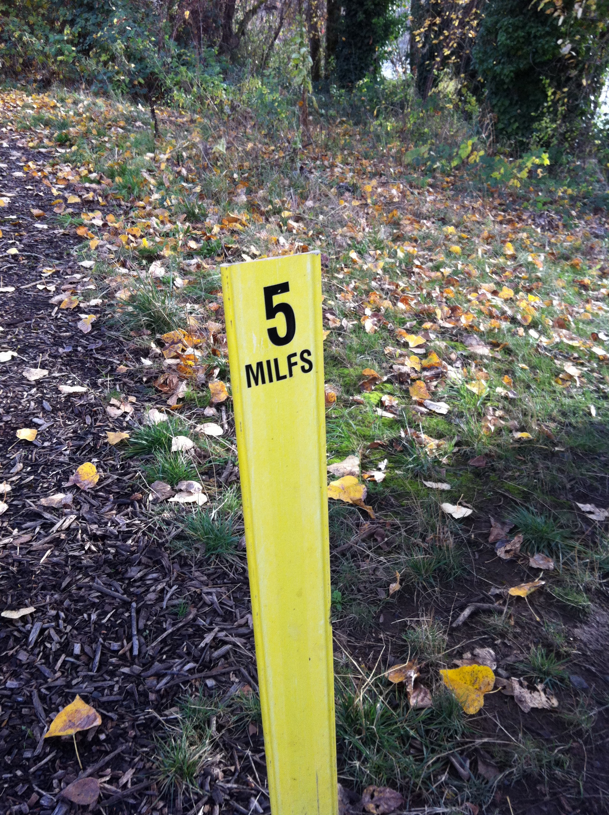
Each 0.5 mile split is marked with a yellow trail marker, where someone has scratched out the decimal point on each post, and has changed the word 'MILES' to read 'MILFS'.  Many of the  markers have nothing written on them, but it's still nice to know that they mark half mile splits.


Bowman Park, Albany, OR

The Bowman Park trail runs alongside the Willamette River.
Location: Park in the Bowman Park parking lot, at the end of NE Geary Street in Albany, OR.

Date run:  many times

Distance:  3.0 Miles, out and back

Pros:  Soft trail, covered with wood chips.  Trail is almost completely shaded.  The trail is patrolled on a regular basis by Albany Police in bikes.  This trail is also used as a practice course for the South Albany High School cross country team.  Close to my home, this is my 'go to' run when I don't have a lot of time.

Cons:  The mosquitoes during some points of the summer are horrendous, and have kept me away on more than one occasion.  Many homeless seem to camp out in areas off of side trails (although, I can't fathom sleeping here and dealing with the mosquitoes in the summer), or else they use the trail en route to someplace else.  I've never had any trouble while on a run, but I am aware that I'm not alone.


Wood chip covered trail alongside the Willamette River.
To find the start of the Bowman park trail, from the parking lot and looking towards the river, head right until you see a well-traveled foot path in the grass, just off of the road that serves as the entrance into the park.  This path turns into a wood-chip covered trail at about the 0.25 to the 0.50 mile mark.
Number of people encountered on run:  Sometimes, I don't see anyone while running.  At dusk, I've passed the Albany Police Department (on bike) sweeping the homeless off of the trail, or I've passed many homeless making their way back onto the trail as the sun starts to set.  In the morning, I've passed homeless coming off of the trail.  There are also many dogwalkers (several are regulars), teenagers out for a walk, and a few bikers.

Summary of run:  I love this trail, except during some parts of the summer, when I've counted about 30 new mosquito bites after a run.  The trail is covered in wood chips for nearly its entire length, and is shaded by large trees for all but 2-3 sections.  The trail starts and stops at a boat launch into the Willamette River, and has one stream that crosses under the trail about half a mile into the run.  Running with my husky, its nice to have a place where he can jump in and cool off.

Most of the dogs being walked along the trail are well-behaved and on-leash, or else their owners curb their dogs as we (my husky and I) run past.

There are a lot of homeless that use this trail, but they've never given me any problems.  Still, I sometimes (half-jokingly) remind my husband that if I were to disappear during a run, he should check my Nike+ account to see where I was last.

Bowman trail.  The trail is traced in the grey dashed line, and then the red dashed line.  Run out from the parking lot on Geary Street.  Run past the Talking Water Gardens paths, and to the loop at the end of the Bowman trail, before returning to the Geary Street Parking lot.  Map courtesy of a screen cap shot from OpenStreetMap.