Showing posts with label 0-4 miles. Show all posts

Monday, August 26, 2013

Downs Park, Pasadena, MD

A fitness station, along the trail.

Location:  Downs Park Outer Loop, Pasadena, MD

Date run: Many times.  I run this loop at least a few times, whenever I'm home visiting family.

Distance: 3.4 Miles, loop

Pros:  This is one of the remaining green spaces in northern Anne Arundel County.  You start and finish the run alongside the Chesapeake Bay.  There's are also fitness stations along a smaller section of the loop, if you're so inclined to do pull ups, sit ups or other calisthenics.  The trail is well marked for distance, every 0.1 of a mile.  The trail winds through fairly typical Eastern deciduous forest.  On runs, I've seen deer, box turtles, pileated wood peckers and other wildlife that are an increasingly rare site in northern Anne Arundel County.
View along the outer loop.

Cons:  The outer loop is paved, which can be a pro, but I find it to be a con.  It's also flat.  Both of these make the run less interesting, for me.  Mosquitoes can be bad at certain points in the summer.  The trail can be crowded, on nice weekends.  There is a $5 per car entry fee, or you can pay $40 for a year round pass.  I don't mind the entry fee all that much.  It grants a bit of peace of mind.  I don't have to worry as much about who I'll encounter on the run, because folks who are on the trail generally want to be out there for recreation.  Otherwise, they wouldn't pay $5 for access.  On other runs in the area, and in my hometown, homeless and drug users are fairly common on the trails.  They've never bothered me, but I've had to have my 'what if' plan, just in case.

Number of people encountered on run:  I usually encounter at least a few folks on this run.  On nice weekends, it can be a bit crowded.

Summary of Run:  Drive into the park, and head towards the bay.  Park in the main parking area, where you'll see a playground to your left and the visitor's center straight ahead.  Walk towards the covered pier (I believe this was originally built as a place for people to paint and draw).  Head down the stairs to the right of the covered pier area.  This is the start of the run.  Green mile markers mark the distance on the outer loop.  The mile markers are split red and green, where the outer loop overlaps with the fitness loop.

I run the loop clockwise.  Once you pass about the 1.0 mile point, you'll more than likely have the trail to yourself on all but the busiest of days.  A bit after the 1.0 mile mark, you'll pass the entry gate, and will have to cross over Mountain Road.  This 'other side' of the park is rarely visited.

The trail winds through fairly typical Eastern deciduous forest.  There seems to be fewer invasive plants and less erosion along stream beds in this park, compared to Patapsco Park, for instance.

There is one very modest climb, as you loop back around to crossing Mountain road, to return to the 'main' section of the park.  The climb is up to a pedestrian bridge that crosses Mountain road, and descends into the main section of the park.

The last 0.5 mile of the run is approaching or along the Chesapeake Bay ~ a real treat at the end of a 5K run!
The run starts and finishes along the Chesapeake Bay.
Distance markers appear every 0.10th of a mile.  The outer loop distance is in green.  Where the outer loop overlaps with the fitness loop, the distance markers are red and green.


Thursday, May 16, 2013

Valley View Trail, Elkridge, MD

Location: Patapsco State Park, Avalon Area in Elkridge, MD

Date run:  many times

Distance:  I usually run a 4.0 mile looped route, but you can extend for many more miles, if desired.

Pros:  Even though you're practically in Baltimore City, the sounds and hustle of the city seem so far away.  Gorgeous, eastern deciduous forest with miles and miles of fun and technical trail options.  There is a bathroom, water fountain and covered picnic shelter adjacent to the parking area.  There is another bathroom and water fountain along the route, if you exit the Valley View trail and turn left (towards the swinging bridge), before turning back to go to the parking area (to the right, when you exit the trail).

Cons:  On the weekends, in particular, the trails can be quite crowded with mountain bikers.  Most are amazingly nice, but some of them aren't quite up on trail etiquette.  These few rude bikers can whiz right past you without warning ~ which makes the run not as quiet and serene as I generally like.

Patapsco State Park is just 3 miles from UMBC, where I spent 4.5 quasi-stressful years of my life.  I was a full time student, trying to find a place to fit in, while sometimes working 3 jobs (day, night and weekend) to try and make ends meet.  Or, I was selling my blood and/or plasma to the local blood bank.  Most people have great memories of their undergraduate years.  Frankly, mine were a blur of work, late night cram sessions, monumental relationship implosions and constant worry about if I would have enough money to cover rent ($276 per month), a car payment ($96) plus other basics.  I brought home $480 each month during these days, which left me $108 for gas, food and anything else I might need.  Running out of shampoo or toothpaste was cause for serious concern.  Adding these non-essentials (in that I didn't need to purchase them every month) to the shopping list could break me for the month.

But, my time at UMBC wasn't all bad.  Part time work with an ecology professor introduced me, for the very first time in my life, to the wonders of the natural world.  It was at UMBC that I realized I wanted to be an ecology professor.

And, UMBC is where I first fell in love with running.  Five nights a week, I would run the UMBC loop, a 2.1 mile jaunt around the campus.  Running was a salve to the stress of studying and scraping by.

Not having money for the movies or eating out meant that I had to find free ways to have fun. I would regularly ride my Dynacraft bike (which my friends with fancy bikes dubbed the 'Dyna-crap') to the Avalon Area of Patapsco State Park, where I would roller blade, mountain bike or run.  The bonsus of riding my bike into the park was FREE ENTRY, baby!  You only had to pay an entry fee if you drove a car into the park.

Twenty years later, I still love coming to this park.  I drive in (and gladly pay my entry fee) and park in the Avalon Area, which provides access to several miles of fairly technical trail.

I usually run the 4.0 mile, orange blaze 'Valley View' trail.  Sometimes, I'll add on the 1.5 mile purple blaze trail for fun.  It's fairly easy to get lost on these trails ~ especially if you don't know how to read trail blazes.  With few exceptions, trail blazes are the only markers on these trails.  Learning how to read trail blazes, a skill that you can acquire quickly and easily, is highly recommended before running these trails.


The trails wind through eastern deciduous forest.  I say that the trails are technical, because there has been a lot of trail erosion.  Exposed roots and rutted trails are the norm.  There is also a fairly steep (for me) ascent up to the ridge, once you hop onto the Valley View trail.  But, the first ascent is for less than a third of a mile.  Not too tortuous.  And, running over the roots, hopping on rocks to cross the streams, and barreling down hills during a descent are all so much fun!

I love this park!

Thursday, December 13, 2012

Dave Clark Trail, Albany, Oregon.

Location: Starts on NE Front Street in Albany, OR, one block from the intersection of Front Street and Oak Street.  There is no parking at this end of the trail.  The trail ends in Monteith Park, where there is ample parking.
Map of Route on DailyMile.com:  http://www.dailymile.com/routes/1375582-running-route
Date run:  December 11, 2012, 11:00 am
Distance:  3.1 Miles, out and back
Pros:  Dry and stable ground, when all of my favorite, local runs are flooded. 
Cons:  In the past, on a summer day's run, I was harassed by someone who didn't seem entirely stable.  I didn't feel entirely safe.
Number of people encountered on run:  0.  It was pouring rain, and I was the only numnut out for the day.  Even my husky was miserable.

I used to love winter running, when I lived in Maryland.  The cold, crisp air smelled so clean and felt great on my asthmatic lungs.  The trails were deserted, and the cushion of fall leaves on the ground would long ago be trampled down from a beautiful mosaic of ankle-twisting leaf drifts, into a a safer layer of crushed organic matter.

But now, I live in Oregon.  I don't mind running in the cold.  I don't mind running in the rain.  I totally mind running in the cold rain.

My favorite trails have been flooded and are unpassable.  They'll likely stay that way until late spring.  Good running gear helps to insulate me against cold, rainy jogs, but the moment I stop running to walk a cool down block or two, the chills that had been lying in wait start to bite and attack.  Running on the roads is not only infinitely less relaxing than running on the trails ~ but Oregon's heavily slanted streets (to direct and manage storm water run-off) cause me to run on a constant tilt, which really hurts my hips.

Another reason that I hate running through neighborhood streets is because it seems that half of the households in Albany, OR burn wood for winter heat.  Or, they burn paper.  Or, they burn things that create thick clouds of ashy smoke that settle low on the street.  My lungs burn.  My inhaler prescriptions get refilled. 

I just can't take running on the streets, anymore.

So I decided to scout out Bowman Trail, just to see if the waters had started to recede ~ which they hadn't.  I could only get about a quarter mile down the trail before reaching the flooded meadow.  The video below was taken in January 2012 ~ but with a few good days of rain, the park can easily become this flooded.


Still needing a run for the day, I decided to hook up with the Dave Clark Trail.  This concrete trail follows the south side of the Willamette River, for 1.5 miles between Bowman Park and Monteith Park.  The City has plans to redevelop the Albany waterfront, and you can begin to see some of the early efforts along the trail.

Starting from Bowman Park, head east, towards the picnic shelter.  Don't cross the bridge to your right.  Instead, go towards the building and open area to your left.  You'll see a very short trail through the blackberry canes that will take you up into the neighborhood.  Take a right on Water Street, left on Pine Street, before taking and a left on Front Street.  Front street runs right into one end of the Dave Clark Trail.

The trail goes past the Willamette Community Garden.  You'll be able to smell the hoppy smell of freshly brewed beer at the Calapooia brewery, one block off of the trail, through an open field.  You'll pass under a railroad bridge (the same one you cross over, on the opposite side of the Willamette River, when running the Takena Park trail), before passing beneath the bridges that connect Albany with North Albany.  You'll skirt the downtown Albany area, before the running through Monteith Park, where the trail ends.

I had only run the Dave Clark trail, once before, and it wasn't the best experience.  During the summer, the trail seemed to be used by a number of homeless.  I actually come across a fair number of homeless on my trail runs, and they always leave me alone.  But, on this one summer day, this one dude didn't seem entirely stable, and I didn't feel entirely safe.  On my recent winter run, it was pouring rain, and I was the only person on the trail.

I think this might be one of my 'go to' runs during the winter, when I can't stand running the streets anymore.  Hopefully, it will help me kill the time until late spring, when the waters recede off of my favorite local running spots.

Sunday, October 21, 2012

Takena Park, Albany, OR

It's always fun running below this railroad trestle ~ even more so when there is a train rattling by overhead.
Location: Park in the Takena Park parking lot, whose entrance is at the intersection of NW Springhill Drive and Route 20, in North Albany, OR.

Date run:  many times

Distance:  3.5 Miles, out and back

Pros:  Soft trail, intermittently bare, covered with wood chips, or covered with gravel.  During the fall, leaves blanket the trail.  The trail follows the Willamette River, on the opposite side of the river from the Bowman Park Trail.  The trail is mostly shaded.  A highlight includes running beneath a raised railroad trestle.

Cons:  During the rainy (winter) season, the trail can flood and become unpassable.

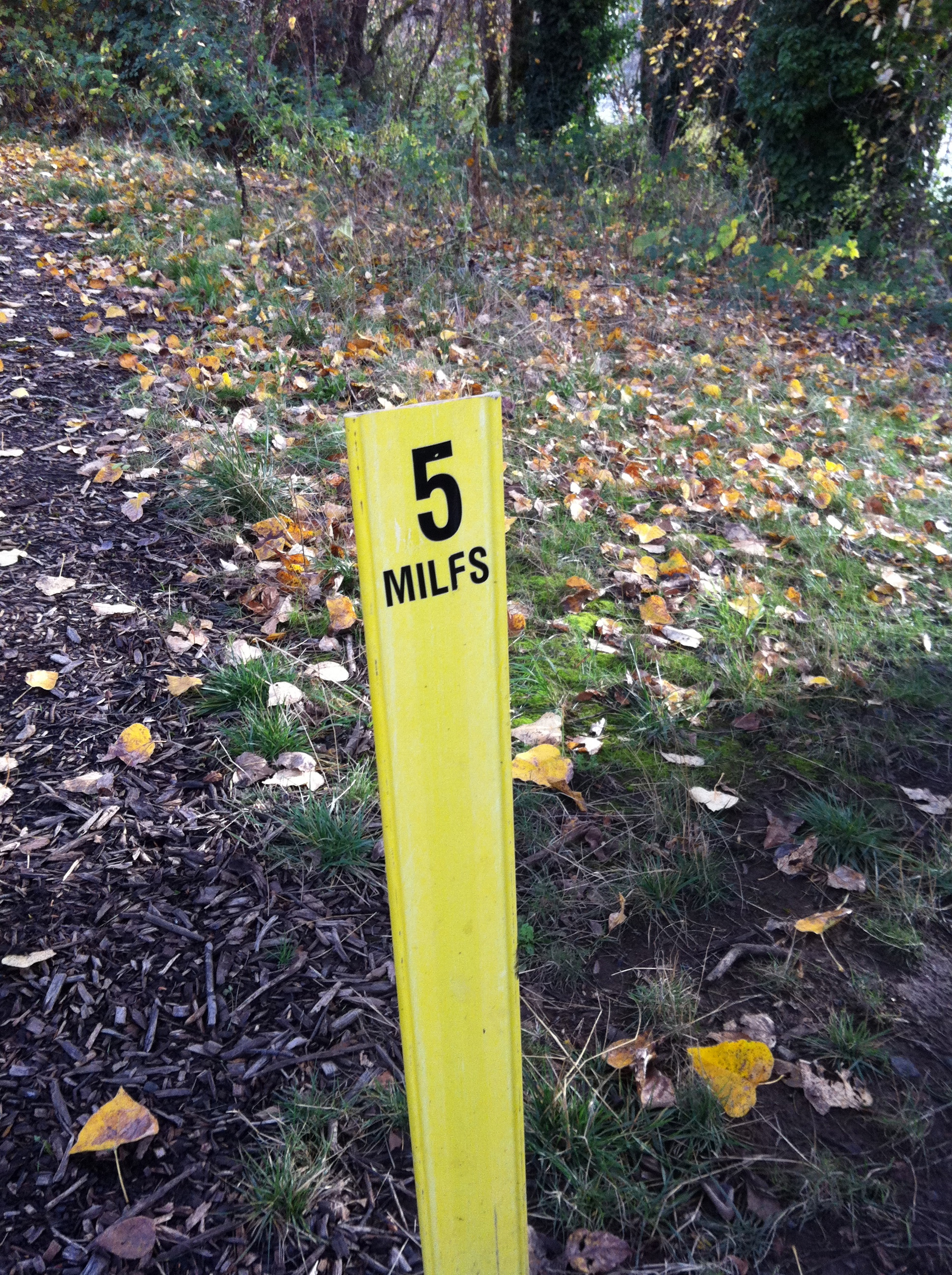
Yellow (half) mile markers along the trail.
Number of people encountered on run:  Sometimes, I don't see anyone while running, but usually, there are other runners, walkers and dog-walkers out on the trail.

Summary of run:  This is my favorite local run.  Located about a half an hour's drive from my house, if I have the time, I go to Takena.  There aren't as many homeless on the Takena trail, compared to Bowman Park, perhaps because this trail is a bit of a walk from town.  The terrain is somehow more interesting to me compared to Bowman, although I can't exactly pinpoint why.

Each 0.5 mile split is marked with a yellow trail marker, where someone has scratched out the decimal point on each post, and has changed the word 'MILES' to read 'MILFS'.  Many of the  markers have nothing written on them, but it's still nice to know that they mark half mile splits.


Bowman Park, Albany, OR

The Bowman Park trail runs alongside the Willamette River.
Location: Park in the Bowman Park parking lot, at the end of NE Geary Street in Albany, OR.

Date run:  many times

Distance:  3.0 Miles, out and back

Pros:  Soft trail, covered with wood chips.  Trail is almost completely shaded.  The trail is patrolled on a regular basis by Albany Police in bikes.  This trail is also used as a practice course for the South Albany High School cross country team.  Close to my home, this is my 'go to' run when I don't have a lot of time.

Cons:  The mosquitoes during some points of the summer are horrendous, and have kept me away on more than one occasion.  Many homeless seem to camp out in areas off of side trails (although, I can't fathom sleeping here and dealing with the mosquitoes in the summer), or else they use the trail en route to someplace else.  I've never had any trouble while on a run, but I am aware that I'm not alone.


Wood chip covered trail alongside the Willamette River.
To find the start of the Bowman park trail, from the parking lot and looking towards the river, head right until you see a well-traveled foot path in the grass, just off of the road that serves as the entrance into the park.  This path turns into a wood-chip covered trail at about the 0.25 to the 0.50 mile mark.
Number of people encountered on run:  Sometimes, I don't see anyone while running.  At dusk, I've passed the Albany Police Department (on bike) sweeping the homeless off of the trail, or I've passed many homeless making their way back onto the trail as the sun starts to set.  In the morning, I've passed homeless coming off of the trail.  There are also many dogwalkers (several are regulars), teenagers out for a walk, and a few bikers.

Summary of run:  I love this trail, except during some parts of the summer, when I've counted about 30 new mosquito bites after a run.  The trail is covered in wood chips for nearly its entire length, and is shaded by large trees for all but 2-3 sections.  The trail starts and stops at a boat launch into the Willamette River, and has one stream that crosses under the trail about half a mile into the run.  Running with my husky, its nice to have a place where he can jump in and cool off.

Most of the dogs being walked along the trail are well-behaved and on-leash, or else their owners curb their dogs as we (my husky and I) run past.

There are a lot of homeless that use this trail, but they've never given me any problems.  Still, I sometimes (half-jokingly) remind my husband that if I were to disappear during a run, he should check my Nike+ account to see where I was last.

Bowman trail.  The trail is traced in the grey dashed line, and then the red dashed line.  Run out from the parking lot on Geary Street.  Run past the Talking Water Gardens paths, and to the loop at the end of the Bowman trail, before returning to the Geary Street Parking lot.  Map courtesy of a screen cap shot from OpenStreetMap.


Beach Run ~ Cape Meares, OR

View looking northwest, towards the ocean.
Location: Park in lot next to beach, on Bayocean Road West, between 3rd Street NW and 4th Street NW, in Cape Meares, OR.
Date run:  October 6, 2012, 7:30 am
Distance:  3.0 Miles, out and back
Pros:  Gorgeous views, quiet beach, relatively even ground (no slant) for a beach run.
Cons:  No real cons were evident on this run.  The fog *just* lifted when I set foot on the beach to start my run.  Driving to the parking area, I wasn’t sure I would be able to see two feet in front of my face.  The air was pretty nippy (36 degrees F).
Number of people encountered on run:  two runners; one family of 5 taking photos

Summary of run:  I spent the night in Tillamook, OR for work, and had to be up and running early, if I wanted to fit this run into my schedule.  I woke up, freezing, at 6am ~ but still managed to muster the enthusiasm for an early morning run (thank you, motel room coffeemaker).  This run, which I found by scanning Google Maps the night before, was about a 15 minute drive from my motel.
I stepped outside of the motel to find that the sun wasn’t yet up (those of you who are normally early risers may not have found this as surprising as me), the fog was heavy and that my windows were iced over.  For a second, I thought about going back up into my room, and crawling beneath the covers.  But, knowing that my 9:30am meeting later that day would involve lots of sitting, a fair amount of stress, and easy access to processed carbohydrates, I scraped the windows and headed out to the coast.

The drive was an eerie.  The road was barely visible with the heavy fog.  I didn’t know where I was going.  I drove past Tillamook Bay ~ where I saw nearly 20 lanterns being held by early morning fisherman, about two per boat, through the thick fog.  At the time, the scene reminded
me of a re-enactmenet of Washington Crossing the Delaware, until I looked up the painting and realized that no one in Washington’s crew is holding a lantern.  I suppose they took that whole surprise attack thing seriously.

I found the parking area, barely stretched, and then made my way out onto the beach.  A quick up and back was all I had the time for, and I soaked in every moment.  I was dressed for a chilly run, and was grateful I had a neck gaiter to pull up and over my face.
View heading south, back towards the parking area.

Normally, I hate running on the beach.  The flat area is too sandy, and the solid area is too angled.  This run was just about perfect.  The hard, wet sand didn’t dip too much to meet the ocean and provided a flat, solid surface on which to run.

I didn’t see a single person on my 1.5 miles run north.  Heading back to the car, I passed one male and one female jogger heading in the opposite direction.  Nearer the parking area, a family of 5 was out taking photos.

The views were incredible.  Unspoiled beach, sea birds hunting for breakfast, capes jutting out into the ocean.

All in all, a great run, and a reminder that nature trumps tv any day.